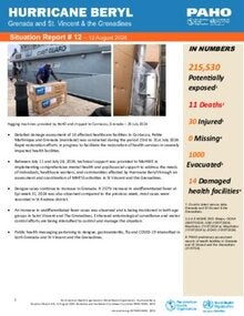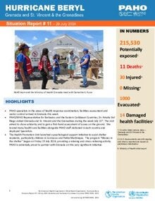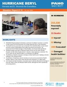
Saint Vincent and the Grenadines is a multi-island state in the Eastern Caribbean. The islands have a combined land area of 389 km2, and the largest of them, Saint Vincent has an area of 344 km2. The Grenadines consist of seven islands and 23 uninhabited cays and islets. The country is divided into six parishes, including one covering all the Grenadine islands.
In 2000 the total population of Saint Vincent and the Grenadines was 113 813 inhabitants; by 2023 this figure had fallen to 103 698, representing a 8.9% decrease. Regarding the country’s demographic profile, in 2023 people over 65 years of age accounted for 11% of the total population, an increase of 3.9 percentage points compared to the year 2000. In 2023, there were 96.7 women per 100 men and 50.6 older people (65 years or older) per 100 children under 15 years of age, as can be seen in the country’s population pyramids, distributed by age group and sex (Figure 1). Considering the population between 15 and 64 years of age to be potentially active (i.e., potential participants in the labor force), this group represented 67.3% of the total population of the country in 2023 (69 815 people). When we add these figures to the potentially passive population (22 505 under 15 years of age and 11 379 over 65 years of age), the result is a dependency ratio of 48.5 potentially passive people per 100 potentially active people. This ratio was 63.0 in 2000.
Life expectancy at birth in 2023 was 70.3 years, lower than the average for the Region of the Americas and 1.1 years higher that in 2000.